(there are perhaps 10-15 more we did not see).
Distance: 150 miles.
Average Speed: 141.5 mph
Average Altitude: 1,751 ft.
 |
| The flight plan was to 1) fly east out of Tri Cities to photo the Windsor Compressor, 2) SW down the Laser pipeline observing the compressor stations there, 3) South to the TGP 300 line East to Lathrop, 4) NNE to Williams Central Station. 5) NE up the Bluestone to Sanford, 6) back the Millennium to home. See the end for the final route we took.... |
 |
| blocked |
 |
| Pilot getting pissed at this guy, shut her down, Piper finally noticed us. Then we got vapor lock and had trouble restarting the engine. |
 |
| Finally airborne! Looking West from Tri Cities. Followed by a U-Turn to the South then East. |
 |
| BU Nature Preserve |
 |
| Ingraham Hill Rd |
 |
| Stainless Tower (L), WSKG tower (R) through haze |
 | |
| We asked Binghamton Regional Airport to help watch for traffic. They requested we squawk on 0322 (nav jargon) |
 |
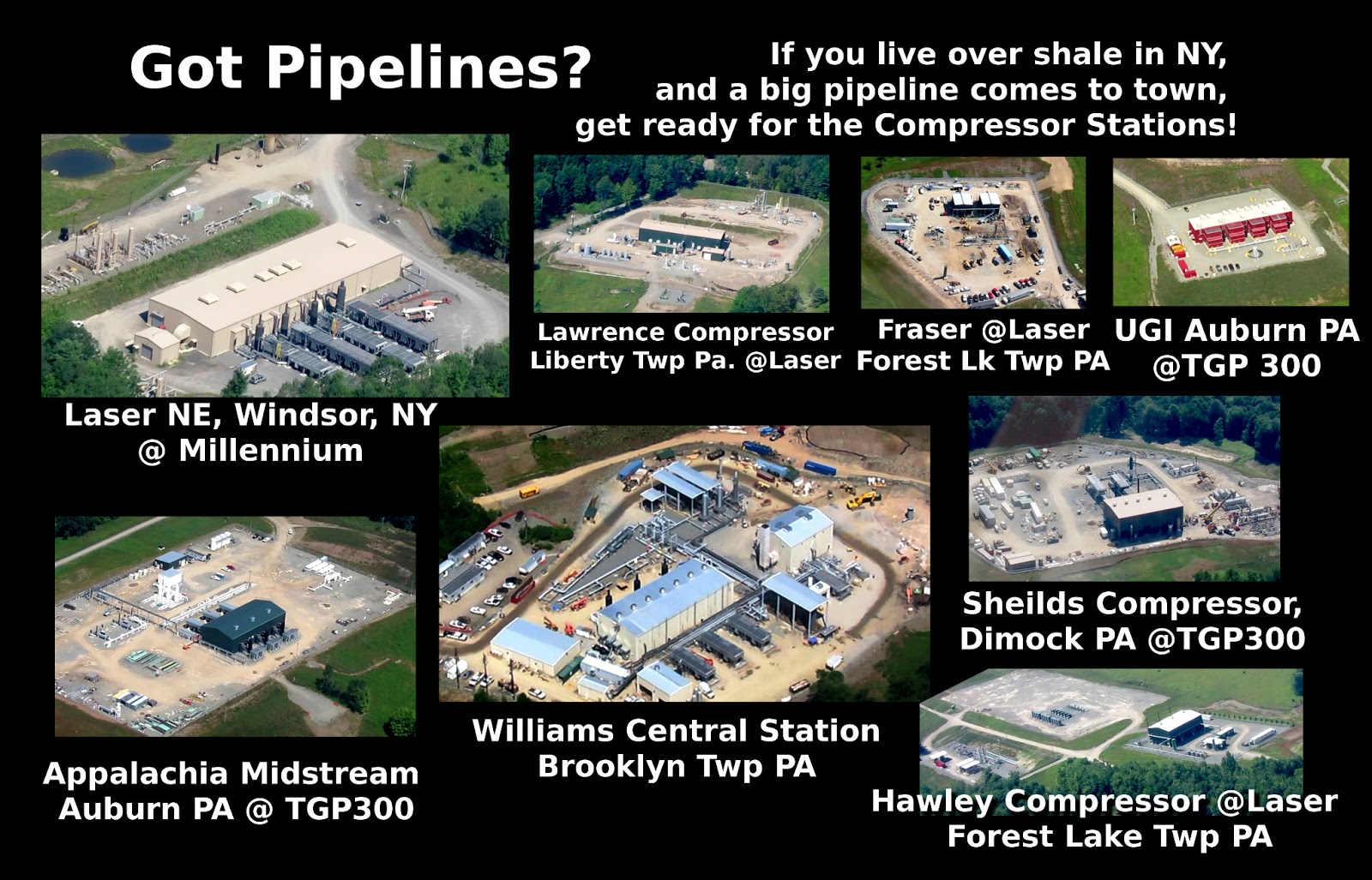
| 1:Massive Windsor Compressor, Dunbar Rd. |
 | |
| 1:The excavated into the side of a hill, most of this is hidden from the road. |
 | |
| 1: Are those solar panels?? |
 |
| 1: This is the one operated by Williams Company which exploded when struck by lightning July 23, 2012. See: http://saneenergyproject.org/2013/07/10/williams-safety-record/ |
 |
| 1: W. Windsor NY, Dunbar Rd. Junction of Laser Midstream and Millennium Pipeline. Why was this not FERC scoped!? |
 |
| 1: W. Windsor NY, Dunbar Rd. Junction of Laser Midstream and Millennium Pipeline. Why was this not FERC scoped!? |
 |
| 1: W. Windsor NY, Dunbar Rd. Junction of Laser Midstream and Millennium Pipeline. Why was this not FERC scoped!? |
 |
| 1: W. Windsor NY, Dunbar Rd. Junction of Laser Midstream and Millennium Pipeline. Why was this not FERC scoped!? |
 |
| Empoundment Pond, not sure what the big tubes are. |
 | |
| 2: This is a new Williams Company facility, Liberty Twp Pa. Lawrence Compressor, at the end of Mt. Valley Rd. This is the site where Vera got mooned by a worker: https://www.youtube.com/watch?v=GaOUqS85sio |
 |
| We were having trouble following the Laser NE gathering line. It's been in the ground for a year and the ROW is overgrown. When we looked at the GPS telemetry data, discovered we were too far south/ |
 | |
| Trying to get bearings |
 | |
| We saw a few drill rigs, not many |
 |
| 3: Frasier Compressor, Forest Lake Twp., Susquehanna County, PA |
 |
| 4: This is Hawley Compressor, Forest Lake Twp. Susquehanna County PA |
 | |
| 4: This is Hawley Compressor, Forest Lake Twp. Susquehanna County PA |
 |
| Another drill rig. We saw maybe 3 this trip, and maybe a dozen a year ago. Really scaled back. . |
 |
| Brine Tanks |
 | |
| Frack Job in Progress. Franklin, Bridgewater, or Forest Lake Twp. Susquehanna County PA Strange storage tanks. |
 |
| Frack Job in Progress. Franklin, Bridgewater, or Forest Lake Twp. Susquehanna County PA |
 |
| 5: Easy to identify this one. So cute, like a childs toy. This is UGI Auburn. |
 |
| 5: Looking East at UGI Auburn. This is what the call the TGP 300 Line. (The ROW cuts through the forest for miles into the distance. (Tennessee Pipeline/Kinder Morgan) |
 |
| Refinery junk. Very common to see this stuff on completed well pads. Dehydration? Condensate (NGLs) removal? H2S scribbing? |
 |
| 5: UGI Auburn. Isn't it cute? |
 |
| 6: I think this is a newer station, Appalachia Midstream Auburn Compressor |
 |
| 6: I think this is a newer station, Appalachia Midstream Auburn Compressor |
 |
| 5: I think this is a newer station, Appalachia Midstream Auburn Compressor |
 |
| I got screwed up with different types of GPS coordinates! Default for Google Maps is decimal degrees, but the devices on the plane want DMS! Doh! That explains why they were so off! So I had to try doing conversions to DMS in my head, e.g., 80/100ths is like N/60? N=? |
 |
| 7: We were looking for the massive Lathrop. How did we miss it? I think this is Shields. The telemetry showed we flew right over Lathrop!!! (oh well-- for next time) |
 |
| 8: There it is.. dun dun, dun dun ("Jaws" shark at the beach music) The massive Williams Central Station. Massive water empoundments in the BG. |
 |
| 8: WCS: My how you've grown! |
 |
| 8: Williams Central Station, Brooklyn/Bridgewater Twp, Susquehanna County PA |
 |
| 8: Williams Central Station, Brooklyn/Bridgewater Twp, Susquehanna County PA |
 |
| 8: Williams Central Station, Brooklyn/Bridgwater Twp, Susquehanna County PA |
 |
| 8: Williams Central Station, Brooklyn/Bridgwater Twp, Susquehanna County PA |
 |
| 8: Williams Central Station, Brooklyn/Bridgewater Twp, Susquehanna County PA |
 |
| 8: Williams Central Station, Brooklyn/Bridgewater Twp, Susquehanna County PA |
 |
| New Milford. Construction trucks kick up a dust cloud as high as we were! ~1000' |
 |
| New Milford. mew well pad |
 |
| New Milford, Tank Farm |
 |
| Hallstead Airport Is that a man camp? |
 |
| A chopper below us flying the Bluestone ROW in the opposite direction. |
 |
| Bluestone @ Sanford. Don't see any compressors yet. |
 |
| An ugly scar cut upon the landscape. |
 |
| Sanford junction between Bluestone and Millennium. |
 |
| Sanford junction between Bluestone and Millennium |
 |
| We are approximately over Sky Lake, looking East. The Bluestone interconnect at Sanford to Millennium is actually North of Millennium, which seems weird to me. |
 |
| Binghamton Alumni Stadium |
 |
| CAFO Factory Farm, Windsor? Kirkwood? |
 |
| Kamikaze Curve rework. |
 |
| Downtown Bingo, State Office Bldg |
 |
| Confluence Park. Why is the Chenango River so milky looking? CAFO runoff? |
 |
| West Side of Binghamton, looking Northwest towards the Cyber Cafe and Tom's Gifts. My old neighborhood. Can see the back of my old house here. |
 |
| The haze finally cleared up. This is looking towards Vestal. |
 |
| Buckeye storage facility off Old Vestal Road, behind Lowe's. Look carefully and you can see a house on an island in the middle of the river. |
 | |
| Passby at Tri-Cities looking East |
 |
| Final Approach |
 |
| Three point landing! |
 |
| This is the approximate route we took. This GPS unit conked out around Montrose, so the last 1/3 was guesswork. |
http://tinyurl.com/n23jetm

7 comments:
thanks, Bill and airplane pilot for doing this; gets me disturbed to see how much the Bastards have infiltrated the lands of the People.
Bill,
This is fabulous! You got some great shots of how beautiful the landscape is before gas development and the mess they leave in their wake. Thank you so much for doing this. The big pad on the Bluestone line is obviously set up to receive something more than what it currently there.
Great pics, Bill. Thanks for doing this. It's ugly, but people need to see the damage done. Great public service.
Hallstead Airport
Is that a man camp?
No just a trailer park with a 93 year old woman living in it that watches everything that those drillers do that live there. Go south about 1.5 to 2 miles to see the trailer park that is over run by campers and right next to a pipe yard that was to become more trailers.
Thanks for showing us what infrastructure looks like. It's such a solid, contained sounding word, contrary to the reality of the actual thing...and that's not considering the volatile compounds or risk of leaks, explosions, etc. An eye opener, for sure.
While they are not in New York (yet?), Tennessee Gas Pipeline has also had a disturbing number of pipeline accidents in recent years.
http://en.wikipedia.org/wiki/List_of_pipeline_accidents_in_the_United_States_in_the_21st_Century
Post a Comment