Drillers targeted specific counties, due to their geological guesswork
about where the "sweet-spots" were in PA.
Leland Snyder and I were discussing the theory:
"The harms of Gas Drilling proportionally follow the activity"
(which may sound a bit like stating the obvious!)
But what we are trying to get to is more like a scientific prediction:
"Where there is Gas Drilling => there will be harms."
This would contradict the often repeated industry statement
that gas drilling can be done in a "safe and responsible" manner.
I've been doing some crude analysis on the List of the Harmed.
These are people who have suffered various health impacts
due to local gas drilling activities.
http://pennsylvaniaallianceforcleanwaterandair.wordpress.com/the-list/
I made a tally of only those incidents in Pennsylvania,
where I could identify a county. There are 100 exactly.
So the idea is to plot where the harms are and correlate this to
where the drilling has been.
This is not very scientific, due to the harms coming in as anecdotes,
the difficulty seeing past Act 13 gag orders, non-disclosure agreements,
and sealed court records. A lot of careful interpretation should
be done here. But certain patterns may be revealed.
Here is where I obtained the number of Marcellus permits per PA county,
here: http://www.pittsburghtoday.org/view_DrillingPermits.html
A couple of anomalies. An incident of harms in Monroe and Union County
in the List of the Harmed but had no Marcellus Permits 2010-2011
Here is the table:
| permits issued 2010-2011, by PA County |
permits issued overall PA 2005-2013* |
% of total permits issued |
#'s List of the Harmed |
Factor Over or Under 1:1 line |
| 1 Huntingdon 1 Lackawanna 1 Venango 2 Bedford 3 Forest 7 Blair 7 Lawrence 11 Allegheny 12 Beaver 14 Luzerne 16 Cambria 16 Columbia 16 Wayne 21 Cameron 27 Somerset 42 Indiana 59 Clarion 65 Jefferson 84 McKean 107 Clinton 126 Centre 127 Elk 132 Armstrong 145 Fayette 146 Sullivan 157 Potter 200 Clearfield 201 Westmoreland 210 Wyoming 229 Butler 395 Greene 510 Washington 583 Susquehanna 660 Lycoming 1,035 Tioga 1,588 Bradford |
254 339 400 435 250 400 835 1,248 1,171 1,160 1,601 2,544 |
0.01% 0.01% 0.01% 0.03% 0.04% 0.10% 0.10% 0.16% 0.17% 0.20% 0.23% 0.23% 0.23% 0.30% 0.39% 0.60% 0.85% 0.93% 1.21% 1.54% 1.81% 1.83% 1.90% 2.08% 2.10% 2.26% 2.88% 2.89% 3.02% 3.29% 5.68% 7.33% 8.38% 9.49% 14.88% 22.83% |
--- --- --- 6 --- --- --- 1 --- --- 2 --- 1 --- --- --- --- 2 3 --- --- --- --- 3 --- --- 2 2 --- 8 2 18 16 2 5 25 |
--- --- --- 200 --- --- --- 6.25 --- --- 8.7 --- 4.3 --- --- --- --- 2 2.5 --- --- --- --- 1.5 --- 0.7 0.7 --- 2.4 0.35 2.5 1.9 0.21 0.33 1.1 |
| 6,956 | 12,460 |
100 |
(* this data supplied via Bill Ferullo, by Bradford County Planning and Grants Commission)
First, let us note that the total number of permits issued (6,956)
does not match a recent number quoted by John Holko (Lenape Resources)
who said the total number of Marcellus wells drilled in PA is 3,700,
which is about 1/2 the number of permits issued just over 2010-2011.
See: http://www.youtube.com/watch?v=S1TQ50Aqoko#t=27m0s
So first we want to look for a 1:1 correspondence between
the % of the total # of drilling permits,
with the % of the total # of harmed.
Bradford County, with the highest number of permits approved
has a nearly 1:1 correspondence. 23% of the permits, and 25% of the harmed.
Washington, Susquehanna, and Bradford county are all well represented
on the List, and have been areas of intense drilling operations.
Next we can look for places which are higher than 1:1 (where there
are more problems then predicted), and places which are lower than 1:1
(where there *may* be the elusive "safe fracking" going on.
But don't jump to any conclusions here until we get more,
and higher quality data.
Susquehanna County has 8% of the permits and 16% of the harmed.
Bedford county only has 0.3% of the permits, but 6% of the harmed.
This could be the place with the worst record in PA,
but again... more data is needed of a higher quality than this.
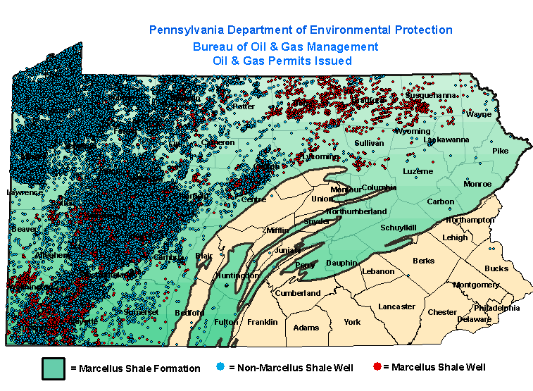 |
| This is where the Marcellus Permits have been issued in PA (red dots) |
 |
| This is well performance. Red=overperforming, blue=underperforming (From http://blog.shaleshockmedia.org/2012/09/02/where-the-marcellus-comes-to-die/) |

No comments:
Post a Comment